 Last Sunday (3-11-12), with the day's temperatures in the Franconia Region slated to get into the low 50's, my daughter, Liz, and I drove North to hike once more up to Lonesome Lake and meaure the thickness of the ice before serious melting gets underway as it feels like spring is a month early. I also wanted to get more winter photos of the lake particularly looking down on it from high up on Cannon Mountain.
 The ice was still solid. The top three inches were slushy due to a relatively thin crust of ice over a layer of liquid water, a deposit from recent rains. Underneath the water was a thick layer of ice.
 Liz coming across the lake with Franconia Ridge in the background.
 For those of you who were cheated out of a winter there are still wintery scenes like this one in the White Mountains. This photo was taken just below the hut on the south end of the lake. A light covering of new snow dusted the mountains on Saturday above the 2700 foot level.
 And it still looks wintery around the hut. The temperature here at 11 am Sunday was 48 degrees and climbing.
 For the umpteenth time here's another photo of Cannon Mountain rising above the lake. The first "Cannon Ball" is to the left. The depression between the Cannon Ball and Cannon Mountain is Coppermine Col. Getting good "aerial" photos of the lake is a bit easier with the foliage off the trees as it is now. The best photos are available from the top of the ledges on the far right hand side of Cannon that are accessed via the HiCannon Trail.
 This is a photo of Lonesome Lake from the top of the first Cannon Ball. The goal of Sunday's hike was to get photos but also to obtain an accurate measurement of the thickness of the ice on the lake and get additional photos, if possible, of the structure of the ice, as well as get depth and water temperature measurements all as a first step in keeping a record of the ice thicknesses, from winter to winter, of Lonesome Lake (just under 3000 feet) and Eagle Lake on Mt. Lafayette at 4,000 feet, and Lakes of the Clouds located at 5000 feet on Mt. Washington.
The project has been inspired by my finding records from the 1930s and 1940s of ice thickeness measurements made by Uncas Gerhard and Slim (Stuart K.) Harris and recorded in several issues of Appalachia. It would be useful, I think, because it's interesting and fun but also to have accurate measurements taken over time as a means to study yearly temperature fluctuations.
 Lizzie looking resplendent on top of the first Cannon Ball with Cannon Mountain (far left) and, barely visible, the summit of Mt. Lafayette behind her.
 South and North Kinsman. Sunday was lovely from dawn to dusk.
 Hiking from Coppermine Col to the summit of Cannon included icy spots.
 Franconia Ridge from the summit of Cannon.
 Lonesome Lake from just above the ledges on the HiCannon Trail. Like the other high "lakes" in the White Mountains which include Speck Pond, the two Carter Lakes, Lakes of the Clouds, Eagle Lake, and even Star lake, Lonesome Lake nestles into a glacially formed depression on a "shelf"; a relatively level area but surrounded by high ridges. With the exception of Lakes of the Clouds all of these lakes are in advanced stages of a naturally occurring successional process. They are all shallow and becoming more so in small increments that progress exponentially. They will eventually revert to forest (unless another glacier happens to pass by).
 Lonesome Lake sits at the lowest altitude of the lakes mentioned above. It has ample supplies of water from several sources including springs, a brook that falls from Kinsman Ridge on the west side of the lake, and runoff from the surrounding ridges including Cannon Mountain. In the photo above it's possible to get a sense of the topography to the east of the lake where you can see a "berm" formed just at the top of the ridge where the flank of the mountain dives down towards Franconia Notch. This berm helps to keep and collect water that eventually feeds the lake. The shelf resembles the upraised palm of a person's hand with a shallow cup in the center. The white line on the floor of the notch is Interstate 93.
Two summers ago I snorkled extensively in Lonesome Lake in an as-yet-unfinished project to identify the aquatic plants growing on the bottom of the lake (see blog entries for July 27, 28, 29 and August 8, 2010 for photos, etc. taken below the lake surface). That project will continue this summer.
 There are fancy tools for cutting through ice quickly but I used what was available at the hut which took some time and energy. I started with a hole 16 inches in diameter.
 Progress was a bit slower than I had expected.
 At 11 am, roughly, the number of passers-by increased exponentially. This group was cheery and curious and chatted for a bit. The guy on the right introduced himself as a "local" who has lived his whole life in Thornton, NH, just down the road, at the foot of Coolidge Mountain, and home of the world famous Hubbard Brook Experimental Forest where I worked briefly in my youth. We shared a few memories and one comment he made interested me regarding a study published by a Thornton resident on white tailed deer. I seldom mention animals in the blog although I mean to. I asked him to send more information if he could and I'll re-publish it here. In the December 1943 Appalachia (p. 548) there's a good article titled: "Animals, More Animals and Further Animals of the Presidential Range" by Uncas (Paul) Gerhard who came across a beaver hiking over the top of Mt. Washington the summer of 1943. I found a beaver laboring over the felsenmeer on the summit in the summer of 1963. How many beavers would you guess hike Mt. Washington? On the other hand, almost every warm blooded, four footed animal native to northeastern North America has been seen on or near the summit of Mt. Washington including: beavers, fox, mink, weasels, chipmunks, skunks, racoons, black bears, white tailed deer, moose, lynx, wildcats, snow shoe hares, porcupines and fishers. I'm leaving out rodents as there's a large number of them as well as amphibians, reptiles, insects including beetles and spiders, and birds. The list of birds who inhabit the White Mountains for various segments of the year is impressive as the birds, themselves, are and of intense interest to many of us.
If you're interested in animals native to the White Mountains a wonderful source of information is a book published by the State of New Hampshire in 1957 and written by Helenette Silver titled History of New Hampshire Game and Fur Bearers. It's available at on-line book sellers.
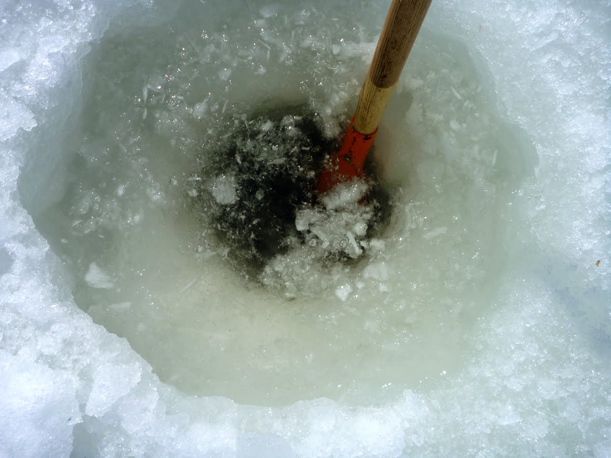 It took 45 minutes to chip down 16 inches.
 Some folks were into hamming it up for the camera. A lot of them asked me if I was fishing!
 I finally broke through (3-11-12, 12 noon) at just under 25 inches (24 7/8 inches). Older records speak of ice 38 inches thick.
 I made quite a mess making this small hole in the ice. There are a couple of interesting things I rediscovered about mountain lake ice. One is that in profile the ice is constructed in layers and is not a homogeneous whole. In this case there were layers of water sandwiched in between solid ice. The other is, of course, that ice forms downwards so that one thinks the water level of the lake is not effected but it is pushed down considerably by the weight of the ice. The lake bottom was at 5 feet, 1/4 inch below the top most surface of the ice including the sandwiched layer of unfrozen water and the uppermost "crust" recently formed over the rain and melt water. The bottom temperature of the water was 36 degrees (F) but the thermometer I used may not be accurate so it leaves the actual temperature in question. My guess would be slightly warmer than that, possibly 38-39 degrees. Many interesting questions arise about the ice's impact on lake water in winter. This winter has been strange in New England, to say the least, and can best be viewed as an anomaly, but I'm curious how much the ice creates a thermal "blanket" on top of the lake water and if under the ice the lake water exhibits marked temperature variations from fall to spring and that would effect plant and animal life.
 By early afternoon crowds were arriving dressed in all kinds of attire....
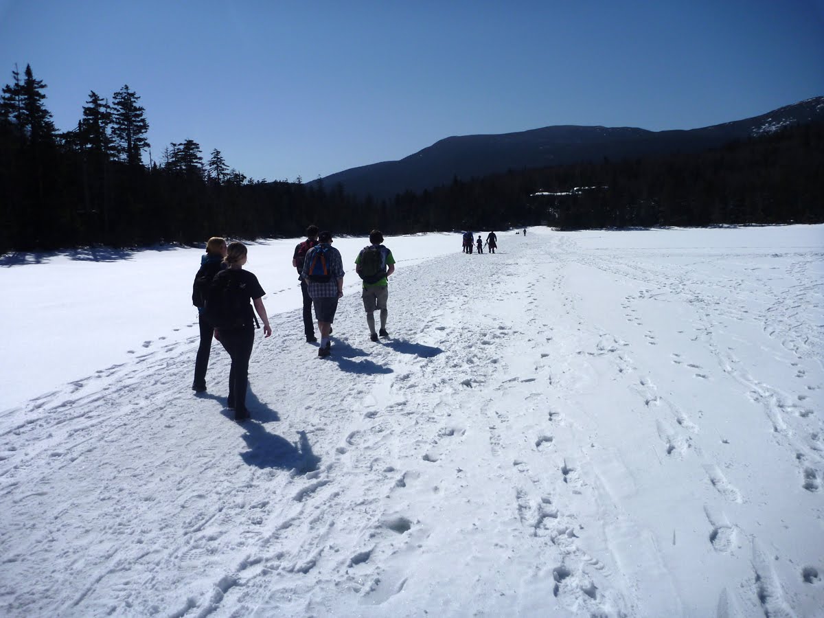 as if they were just out for a stroll. The lake passage was like a city sidewalk. Chad, the hut caretaker, posted warnings about the safety of the lake ice advising hikers to use the trail that circles the lake but the preferred route was the straight line.
 Liz and I headed down in mid afternoon as the light and the snow softened.
 The snow on the trail was soft enough for all-out running making for a quick descent.
No comments:
Post a Comment